Summer Snow and Brisk Southerlies: A Chilly Turn for Hobart
A Sudden Snap in the Capital
Hobart is set for a distinctly brisk Thursday as a cold front moves through the region, bringing unseasonably cool temperatures and even a touch of white to the higher peaks. Residents should prepare for a significant drop in temperature compared to the usual February warmth, with the city expected to reach a maximum of just 18°C today. This cool change comes as a sharp contrast to the typical summer conditions enjoyed earlier in the month.
Morning Showers and Southwesterly Gusts
The day will begin under partly cloudy skies with a medium chance of showers, most likely during the morning and early afternoon hours. These showers are being driven by a cool southwesterly flow developing in the wake of a cold front that crossed the state on Wednesday evening. The Bureau of Meteorology suggests a 50 to 60 percent chance of rain, though totals are expected to be light, generally under a few millimetres.
Wind conditions will be a dominant feature of today’s weather. Forecasters expect northwesterly to southwesterly winds sustained between 25 and 35 km/h throughout the day. By late afternoon, the wind is expected to shift more consistently to the southwest, adding a significant wind chill factor to the 11°C overnight low. In the Derwent Estuary, mariners should expect westerly winds of 15 to 20 knots with seas around one metre.
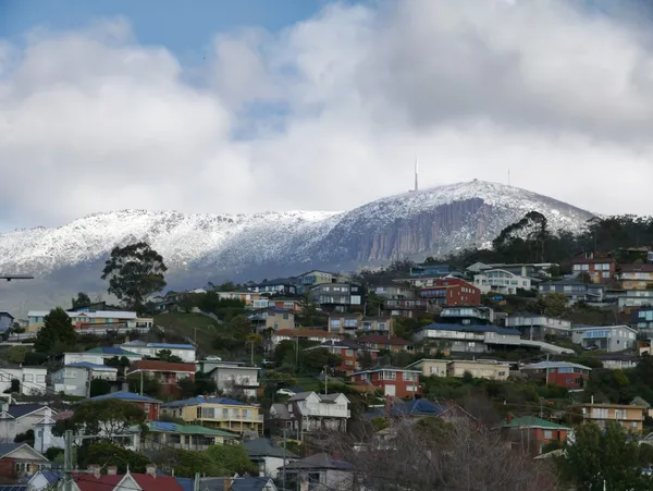
Snow on kunanyi / Mt Wellington
The most striking feature of today's forecast is the prediction for unseasonable snow. Meteorologists are tracking a cold airmass in the Southern Ocean that is expected to bring snow showers to elevations above 1000 metres as the front rushes through. This means the 1271-metre summit of kunanyi / Mt Wellington is likely to see a dusting of snow—a rare but spectacular sight for mid-February. Visitors planning to head to the pinnacle are advised to prepare for sub-zero conditions and high winds on the mountain.
Evening Outlook and Weekend Preview
As we move into the evening, the cloud cover is expected to persist, though the likelihood of rain will diminish as the system clears to the east. The southwesterly breeze will continue to keep conditions cool, setting the stage for a chilly night across the Greater Hobart area. Looking ahead, a strong ridge of high pressure is forecast to build over Tasmania on Friday, which should bring more stable conditions and a gradual warming trend for the coming weekend.
Today's Weather at a Glance:
- Maximum Temperature: 18°C
- Minimum Temperature: 11°C
- Conditions: Partly cloudy with morning showers.
- Wind: 25-35 km/h southwesterlies, easing slightly by nightfall.
- Special Interest: Snow expected on kunanyi / Mt Wellington above 1000m.

Zen in the Park and Tall Ship Adventures: Your Hobart 'What’s On' for Tuesday

Sun, Strength, and Simpler Scripts: Your Hobart Morning Briefing
Lane Closures and Speed Restrictions: Commuter Update for Southern Outlet and North Hobart